


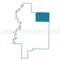
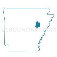
Pumpkin Bend Precinct 19, Woodruff County, Arkansas
About
Outline

Summary
| Unique Area Identifier | 528549 |
| Name | Pumpkin Bend Precinct 19 |
| County | Woodruff County |
| State | Arkansas |
| Area (square miles) | 54.32 |
| Land Area (square miles) | 54.25 |
| Water Area (square miles) | 0.08 |
| % of Land Area | 99.86 |
| % of Water Area | 0.14 |
| Latitude of the Internal Point | 35.31651110 |
| Longtitude of the Internal Point | -91.12382310 |
Maps

Graphs
Select a template below for downloading or customizing gragh for Pumpkin Bend Precinct 19, Woodruff County, Arkansas


Neighbors
Neighoring Voting District (by Name) Neighboring Voting District on the Map
- Brushy Lake Voting District, Cross County, AR
- Fair Oaks Voting District, Cross County, AR
- Fakes Chapel Precinct 20, Woodruff County, AR
- Gourdneck Citizenship Voting District, Jackson County, AR
- Hickory Ridge TWP Voting District, Cross County, AR
- McCrory Precinct 17, Woodruff County, AR
- McCrory Rural Precinct 15, Woodruff County, AR
- Morton Precinct 14, Woodruff County, AR
- North Rural Augusta Precinct 4, Woodruff County, AR
- Tupelo Voting District, Jackson County, AR
Top 10 Neighboring County Subdivision (by Population) Neighboring County Subdivision on the Map
- Augusta township, Woodruff County, AR (2,598)
- De View township, Woodruff County, AR (2,432)
- Hickory Ridge township, Cross County, AR (498)
- Breckenridge township, Jackson County, AR (478)
- Cow Lake township, Jackson County, AR (377)
- Brushy Lake township, Cross County, AR (339)
- Barnes township, Woodruff County, AR (316)
- Pumpkin Bend township, Woodruff County, AR (276)
- Dent township, Woodruff County, AR (256)
- Fair Oaks township, Cross County, AR (167)
Top 10 Neighboring Place (by Population) Neighboring Place on the Map
Top 10 Neighboring Unified School District (by Population) Neighboring Unified School District on the Map
- Wynne Public Schools, AR (14,318)
- Newport School District, AR (11,706)
- Cross County School District, AR (3,705)
- McCrory School District, AR (3,516)
Top 10 Neighboring State Legislative District Lower Chamber (by Population) Neighboring State Legislative District Lower Chamber on the Map
Top 10 Neighboring State Legislative District Upper Chamber (by Population) Neighboring State Legislative District Upper Chamber on the Map
Top 10 Neighboring 111th Congressional District (by Population) Neighboring 111th Congressional District on the Map
Top 10 Neighboring Census Tract (by Population) Neighboring Census Tract on the Map
- Census Tract 4804, Jackson County, AR (4,669)
- Census Tract 4901, Woodruff County, AR (4,486)
- Census Tract 4902, Woodruff County, AR (2,774)
- Census Tract 9503, Cross County, AR (1,544)